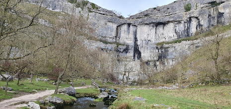
MALHAM 26th November 2023
It was clear all day but Malham was in a sombre mood.
Some miles before Malham the first party left the coach at East Martin. Steph led her party along the winding Leeds-Liverpool Canal path to Gargrave and then leaving it to follow Aire Footpath and Pennine Way to Malham, a good distance of 10.5 miles with stops for photos at Carpenters Lock and Canal Lane Bridge.
Stuart’s group left early at Gargrave to cross in a roughly north easterly direction through Friars Head to Winterburn Reservoir. From the northern end of the reservoir they picked up the Dales Highway to Weets. From the Top of Weets they ‘descended’ to the Top of Malham Cove and then finally down to the village.12 miles.
At Kirby Malham, Mike J’s group was the next party to leave the coach. By a more direct route they were too heading for the long ridge of Weets Hill and Weets Top. From there they crossed Smearbottom Lane at Street Gate and down to the top of Malham Cove. They followed the same route down into the village. 8.5 miles.
From Newfield Bridge Anne and Helen followed the Pennine Way on the eastern side of the twisting River Aire all the way from Newfield Bridge Hall near Eshton Moor.
The Oldhams left the coach Airton heading west for High Barn and then the spectacular Scaleber Force at Settle. From there they headed up to Stockdale Lane area with the the Attermire Caves and across Black Scar, working their way over to Malham. 15 miles.
Braving all his warnings about slippery limestone, Paul led his group to the bottom of the Cove and up the slippery steps to across the perilous limestone pavement, and then through the dry valley to Malham Tarn. From High Trenthouse they did a full circuit of the Tarn, including an inspection of the Tarn Cave Spiders and returned to Malham by the south west Pennine Bridleway and Long Lane. 10 miles.
From Malham village Mike’s group stated up Butterlands Barn Path for Pikedaw Hill – a low hill with a very obvious summit cairn and the Nappa Cross. They found the cairn and also found various mine shafts, holes and the 23 metre Pikedaw Calomine Cavern/Mine. For obvious reasons it was capped but it was not difficult to imagine caves and the conditions below. They continued over to the Water Sinks and round to descend to Malham by Shorkley Hill and Goredale Bridge. 8.5 miles
All returned safely, some with plenty of Yorkshire mud, but happy with a successful, and dry day’s walking.
Mike
Thank you to the photographers who kindly illustrate the walk account: Anne, Chris, Dawn, Geoff, Mike B, Mike C, Mike J, Pam, Rick , Simon and Stuart,
To open the Album click here-
4.00 p.m. departure
5.00 p.m. departure
5.00 p.m. departure


Comments
Post a Comment